File:2025-01-29.Gulf of Understanding.adj-1600pxw.jpg
Jump to navigation
Jump to search

Size of this preview: 800 × 421 pixels. Other resolutions: 320 × 168 pixels | 1,600 × 842 pixels.
Original file (1,600 × 842 pixels, file size: 435 KB, MIME type: image/jpeg)
Summary
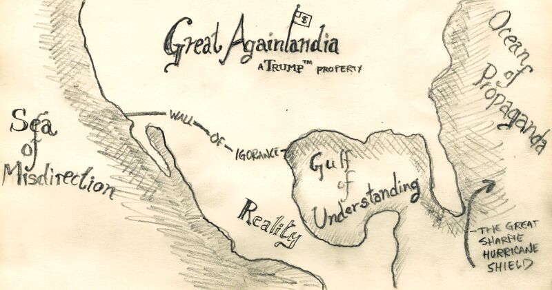
- title: "Gulf of Understanding"
- artist: Woozle
- subject: US/president/EO/2025/01/20/45
- posted: 2025/01/29 2025/02/11
Description
a crude pencil-drawn map of the continental US and Mexico
The US is labeled "Great Againlandia (a Trump™ property)", separated from "Reality" (fka Mexico) by the Wall of Ignorance (spelled wrong), and together they enclose the "Gulf of Understanding". To the west is the Sea of Misdirection, to the east is the Ocean of Propaganda, and off the tip of Florida is The Great Sharpie Shield
File history
Click on a date/time to view the file as it appeared at that time.
| Date/Time | Thumbnail | Dimensions | User | Comment | |
|---|---|---|---|---|---|
| current | 01:52, 9 February 2025 | | 1,600 × 842 (435 KB) | Woozle (talk | contribs) | {{c/date|2025-01-29}} * '''title''': "Gulf of Understanding" * '''artist''': {{woozle}} * '''subject''': US/president/EO/2025/01/20/45 |
You cannot overwrite this file.
File usage
The following page uses this file: